
Birni N’Konni Fm
Type Locality and Naming
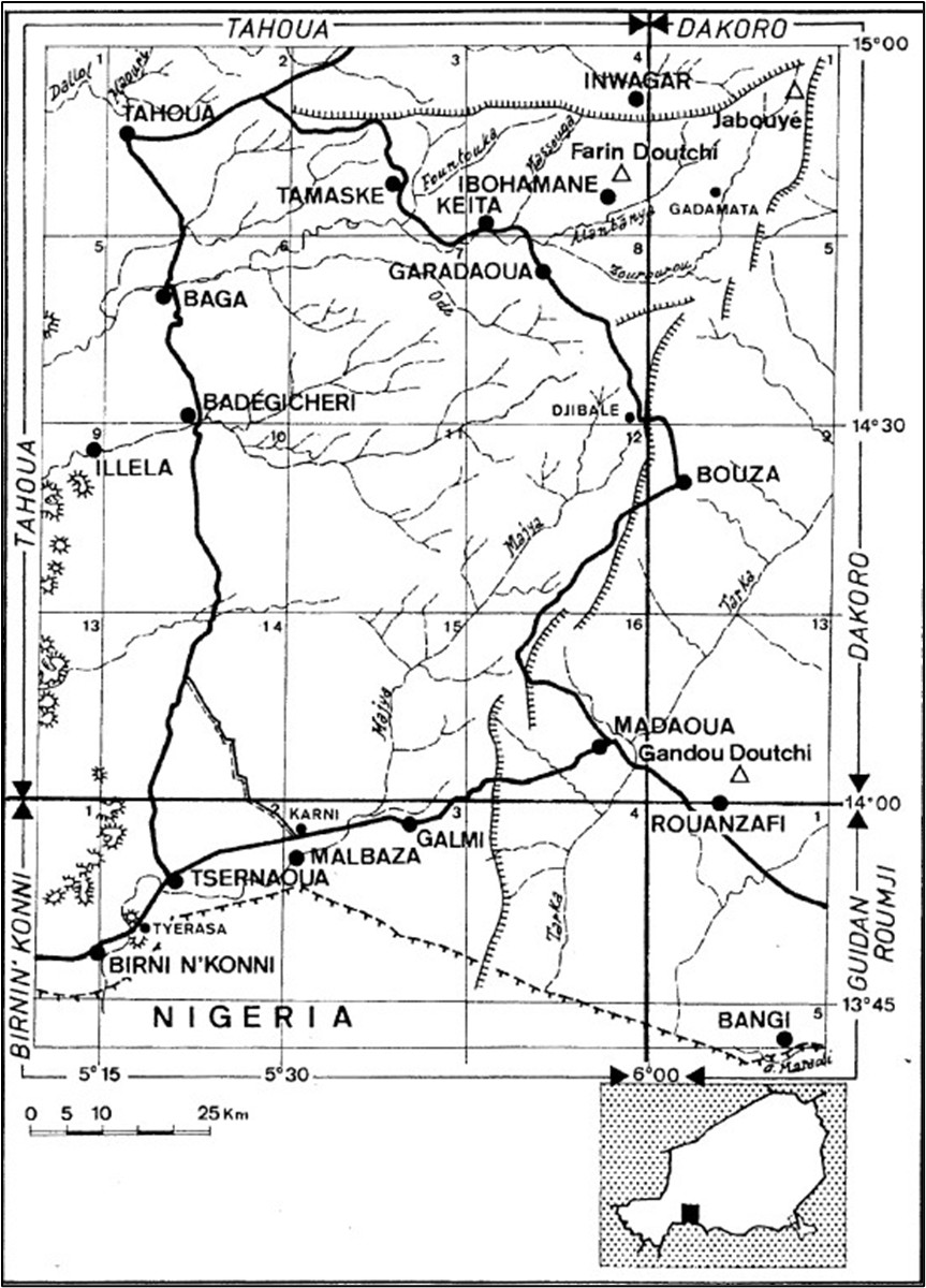
The most complete sections are observed about 5 km east of the town of Birni N'Konni on the flanks of the hills of Tyerasa Mango and Tyerasa Goune (Fig. 7-21). This name was proposed by Dikouma (1990) after studying the stratigraphy of Ader Doutchi North and by analogy with the Sokoto Group of Nigeria. Dallols Gr.
[Figure 1: Map of the Birni N’Konni and Tahoua regions. The Tyerasa type locality of the Birni N’Konni Fm is shown in the bottom left corner (Source: Hanon, 1990)]
References: Pougnet, 1949; Hanon, 1990; Dikouma, 1990; Moody, 1997; Beauvais et al., 2008; Heckmann, 2019; Ousmane et al., 2020.
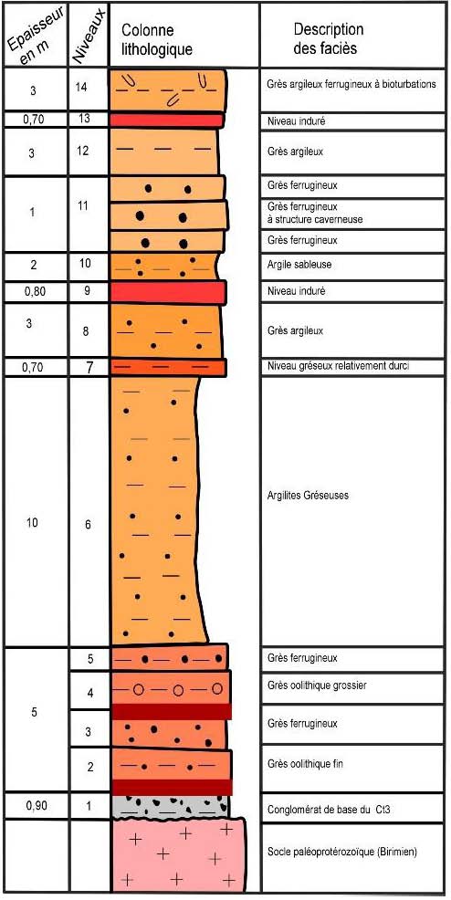
Synonym: "Grès argileux du Moyen Niger (Ct3)" (Fig. 2) [Middle Niger clay rich sandstone] together with "Série argilo-sableuse à lignites (Ct2)" [lignitic clay rich sandstones]. Also, the “Gaya Formation” of Pougnet (1949).
[Figure 2: Ct3’s lithologic column around the capital Niamey (Source: Ousmane et al., 2020)]
Lithology and Thickness
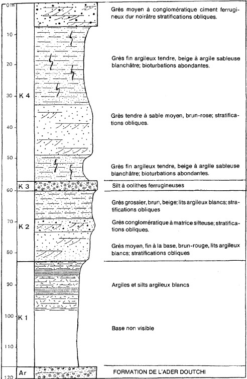
Sandy-argillaceous set, presenting facies varying between practically pure clays and conglomeratic sandstones. Its thickness is 480 m. In the Birni N'Konni region, the thickness of the formation is about 120 m.
Four Members are present, from top to bottom (Fig. 3):
- K4: 58 m in Tyerasa; decametric alternations of the following two facies:
▪ Fine-grained clayey sandstone of white or beige quartz; abundant, white clay matrix; branched tubulations with a pink silty clay filling, plentiful in some banks (bioturbation).
▪ Soft pink sand and sandstone; medium to a very coarse grain of angular quartz; ferruginous clay binder not very abundant; oblique stratifications, decreasing in grain size, rare bioturbation.
In the region of Birni N'Konni, the upper 8 meters of the Member are made up of a slab of a dark ferruginous conglomeratic sandstone with oblique stratifications.
- K3: from 0 to 4 m; fine ironstone silt; locally abundant ferruginous oolites; this thick and hard horizon is evident in the topography.
- K2: from 20 to 25 m; fine, medium, coarse, pinkish brown, brick red sandstone; fine grain at the base, becoming coarser towards the median zone of the member or appearing conglomeratic facies (with elements up to 1 cm) of rolled quartz and rare clay pebbles, then gradual passage to finer and finer sandstone and, at the top of the Member, has sandy clays; Oblique stratifications, sorting of grains. In the north of the Birni N'Konni region, the conglomerates are more abundant and have more angular elements; locally, they constitute the entire Member.
- K1: from 30 to 60 m; compact white kaolin clays; often poorly marked stratification; locally very fine alternations (millimeters or infra-mm) of white clays and very fine white sands, parallel laminations. North of parallel 14° 30', the thickness of layers between the top of Member K1 and the top of the underlying Ader Doutchi Formation reaches 60 m. The lower part of this interval does not show any outcrop for about 30 m.
[Figure 3: Stratigraphic section of the Birni N’Konni Fm at Tyerasa (Source: Hanon, 1990)]
Relationships and Distribution
Lower contact
Underlying unit is the Ader Doutchi Fm
Upper contact
Overlain by Quaternary
Regional extent
Iullemmeden Basin
GeoJSON
Fossils
Fossils of gastropods and lamellibranchs epigenized in goethite and hematite are quite frequent at Member K3. Pila wernei (Philippi), Unio sp., Corbicula aff. africana (Krauss) and Corbicula sp. could be determined in Toudou and Tyerasa Goune; these fossils have no precise stratigraphic significance. Tubular perforations in the clayey sand of the K4 Member can be attributed to old burrows or root ducts.
Age
Depositional setting
Continental. The sedimentological characteristics of the different facies encountered in the formation suggest shallow-water conditions with fluctuating energy levels and corresponding to the coastal, lake, and fluvial environments.
Additional Information
Top formation of the Continental Terminal.